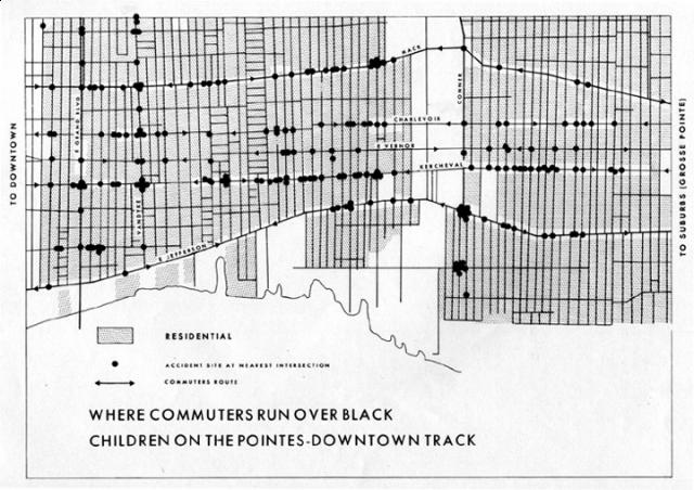

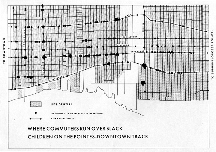
Where commuters run over Black children in Detroit. By the Detroit Geographical Expedition and Institute: http://makingmaps.files.wordpress.com/2008/02/bunge_runovermap.jpg
This post written together with Chris Schweidler.
This Fall, together with DataCenter, we began developing the Civic Maps Toolkit to orient Community-Based Organizations and Grassroots Groups to the opportunities, tools and even limitations of civic mapmaking. The Center for Civic Media and DataCenter are jointly managing the toolkit development and our team of content writers includes students from the Center and enrolled in Center courses and interns with DataCenter.
At the beginning of our process, we announced the project and invited people to join in planning and writing the Toolkit. We are approaching the end of the semester and have a draft website, a series of drafts of case studies and are beginning to draft the introductory and framing sections. A small sample of the case studies includes: the Winnemem Wintu’s use of mapping in their land rights struggle; Picture the Homeless’s vacancy mapping in NYC for housing justice; The Detroit Geographic Expedition’s use of mapping to make visible the geography of racism in Detroit (featured image above); Harassmap’s use of mapping to build a campaign to reduce sexual harassment in Cairo.
Among our team, we’ve been challenging ourselves to understand and explain how CBOs and grassroots groups are using mapping work to build movements, change narratives, and affect policy. In the next few months, we’ll be finalizing this round of content and sharing our materials on the site. We plan also open the site for contribution so that people can add their own examples of civic mapping.
Project Overview
As GIS and map literacies become more widespread, maps are increasingly important tools across all spheres of civic life. There are multiple and overlapping histories of communities using maps for civic action, from participatory GIS to environmental justice, from indigenous land claims to crisis mapping. Currently, there is an explosion of new civic mapping tools and practices. For example, Open Street Maps allows large numbers of people to participate in improving an open map base; Grassroots Mapping provides tools for community-created aerial imagery layers; Ushahidi’s hosted Crowdmap service allows quick and easy creation of incident report maps; etc. The Center for Civic Media, together with DataCenter, is reviewing and synthesizing this broad and expanding field to produce a Civic Maps Toolkit. This toolkit will be designed to orient grassroots groups and small organizations to the possibilities of civic mapmaking. The Civic Maps Toolkit will provide: 1. a concise overview of the field and subfields; 2. case studies; 3. interviews with practitioners; 4. a resource guide; 5. a gallery of beautiful civicmaps.
The CivicMaps Toolkit
The Civic Maps Toolkit will be an online resource designed to introduce novice users to the field of civic maps, support the integration of mapping into their work, and provide clear overviews of specific mapping tools. The Toolkit will include: an overview to introduce key issues, processes and uses of mapping; individual case studies of how mapping has been used to achieve concrete outcomes (e.g. impacts, wins, etc.); interviews with practitioners; and a resource guide with overviews and links to existing tools, curriculum, and other materials.
Overview of the field: The overview will provide a framework for the overall toolkit. It will be broken into discrete, concise sections, written in an accessible style. It will draw from both published scholarly and practitioner literature, as well as from a series of interviews with practitioners (described below). We will examine existing frames, tools, approaches, projects, open technologies, initiatives, and gaps in the areas of public participation GIS, participatory mapping, grassroots mapping, and civic mapping. This overview will serve as the introduction to the completed work, and will be written for a popular audience, specifically grassroots orgs seeking to utilize mapping in their work.
Case studies: Case studies will provide overviews of real world projects that utilized mapping, including their goals, how they engaged communities, technologies used, and the impact of their mapping work. The project team will also create a template that can be used by practitioners in the field to submit their own case studies to the site. Specific practitioners will be invited to submit case studies, to be curated by the project team.
Interviews: Interviews will be conducted with practitioners in the field. The interviews will not only provide material that informs the overview, but (with the agreement of the interviewees) will also be published on the project site. These interviews will provide visitors with insight into the opportunities and challenges of grassroots mapping.
Resources: This section will provide visitors with links to a variety of resources that can support their use needs, such as technologies, curriculum, and literature.The project team will create short (3-5 sentences) resource overviews, with links to additional information and materials.
Gallery: As the project team (and others we hope), complete the first iteration of the project, we hope they will also contribute to a curated gallery of civicmaps to be shared on the site.
Civic Maps Team (so far): Luis Capelo, Sasha Costanza-Chock, Rodrigo Davies, Catherine D’Ignazio, Arlene Ducao, Theo Gibbs, Becky Hurwitz, Joanna Kao, Aditi Mehta, Pablo Rey, Benjamin Rubin, Aviva Rutkin, Chris Schweidler, Liz Tyson.
Interested in getting involved? Questions about the project?
Drop us a line! Email Chris, chris@datacenter.org or Becky, beckyh@media.mit.edu.