
This talk kicks off our Civic Lunch Speaker Series for Fall 2013. Live blogging contributed by Catherine D’Ignazio, Erhardt Graeff, Becky Hurwitz, and Rahul Barghava.
About Annette Kim
Annette M. Kim researches the spatial processes of major institutional change, particularly the reconstruction of property rights and planning paradigms in rapidly urbanizing regions. Her publications include studies of the first generation of private real estate developers in Vietnam, the political struggle for land and compensation on the urban periphery, and the contest for sidewalk space in the midst of migrant street vending and populist urbanism. Currently, she directs the research group SLAB which is developing methods of spatial ethnography and critical cartography in order to re-conceptualize urban space and find more inclusive and humane ways to design and govern the 21st century city.
Professor Kim received her Ph.D. from the University of California, Berkeley in City and Regional Planning as well as a concurrent M.A. in Visual Studies; a Master in Public Policy from Harvard University; and a B.A. in Architecture and Studio Art from Wellesley College. Professionally, she has been an architect of affordable housing, a construction project manager, and jury member of international urban design competitions. She has also served as a consultant to the United Nations Centre for Human Settlements, the World Bank, African and Asian governments, as well as community-based NGOs.
TALK
Kim shows a graphic about the explosion of visualization in the past decade. What she’s doing with SLAB is taking a step back and thinking about what they are doing with those visualizations. She shows a graphic of tweets happening one hour before and after the major earthquake in Japan. But it looks like the maps we’ve seen since the 1970s about globalization that illustrate things that we already know. She encourages us to push for visualizations that show us new things. Much of the data for these maps is generated in urban centers.
She looks instead toward “Visual Social Sciences,” which are critical, humanistic, and integrate a kind of public service. The social sciences have been slower at adapting. This is the mission of SLAB:
1. To be critical of what we are representing and not representing,
2. To have a humanistic focus; it’s really about people, and this must not be lost with aesthetics, and
3. To engage with institutions for public service
“Who and what have we missed in our visualizations?” Kim asks.
For her, urbanization means migration. When we say urbanization we mean a shift into urban centers. The essential question is how society transforms its property rights.
We can’t live in cities that same way anymore. Density is more people with diverse spatial projects, trying to make a life in the same space. Density is changing the way we view our cities.
The essential question is: How does society transform its property rights about who can use what space, for what purposes, under what conditions, with what entitlements and responsibilities?
This is the context where SLAB is trying to visualize these phenomena. The first generation of work has focused on sidewalks. They are often the most overlooked spaces in cities. Much of the research has focused on the plaza or on monumental places as civic space.
Sidewalks are one of the spaces we have overlooked. They are humble, ubiquitous, and very narrow. They represent a different type of space and social interaction. On sidewalks, people brush against each other and make contact, and they have less people on them overall compared to other spaces.
She asks if streets and sidewalks are transportation corridors? Or also places for leisure, eating, socializing, vending?
What if we transform spaces from privileging cars (say, in Times Square) to privileging leisure, eating, socializing, vending. There have been a number of urban experiments in transforming spaces from roadways to public spaces for leisure. She shows examples from numerous cities.
Bogota’s “Ciclovia:” the mayor over the past years have been converting roadways for leisure. In San Francisco, there has been intention of taking over roadways and to convert them into different spaces for leisure.
Park(ing) Day around the world: the artist group REBAR started a movement to create temporary public parks. Participants put quarters in meters and created pop-up parks with turf and benches, where they had had picnics and other activities in those reclaimed spaces. This has set off an annual world parking day across the globe, touching a nerve indicating that we want to live in cities in different ways.
Another aspect of this is the food truck trend where you see another different use of sidewalks and public spaces. There have been varied responses rejecting and embracing this trend. Food trucks have also been met with conflict from storefronts.
Food trucks have been around before they were trendy, and their use of public spaces and sidewalks is contested. Activist groups advocate for the rights of street vendors and food carts to use sidewalks and to work out ordinances around their use of sidewalks. An example, the Street Vendor Project, started in NYC and now has a chapter in LA.
There have been struggles with food vendors in China. There was a big riot set off by the beating of a pregnant street vendor in China. There is a global struggle to rethink public space in the face of immigration. Where is the public space for migrants?
When we think of public space there is often a “narrative of loss,” e.g. big corporations are taking over public spaces. Kim shows a slide from HSBC plaza in Hong Kong which is empty on weekdays and totally full on weekends with service sector maids. This has created huge controversy in Hong Kong. There is a mass movement of the service sector, maids and other workers, and they use public spaces to socialize. They camp out all day in such spaces, and also in large public malls.
Some would call this an insurgent practice or “everyday urbanism.” Others would call it cultural practice or contestational. The maids are not trying to challenge their social status but it is more political than simple cultural practice.
Professional urban planning plays an important role in how to conceptualize the phenomenon. There is still this view of sidewalks playing a role as transportation corridors. She shows fascinating diagrams of professional spatial bubble diagrams that tell you how much space people need. We keep rationalizing the way we plan sidewalks as though it’s rational and scientific. Architecture takes a similar approach, drawing and designing images of cities privileging the built form absent images of people.
She notes that architectural designs of Hong Kong show a city of 10 million people but the diagrams and plans never show any people. Architectural diagrams that do show people show them doing the appropriate activities. Design firms and local firms often develop city plans that do not show people living in the cities.
These diagrams shape what is our notion of the “appropriate” city. They shape what we see. They privilege the built form. In other words, there is a power in our visual conventions to:
1) To shape what we notice,
2) To conceptualize what we see, and
3) To construct our world.
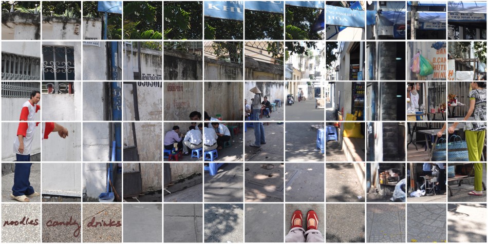
There is a disconnect with the images of the city in terms of designing art and how they really are. She shows an image of Ho Chi Minh City where no one is sitting on the available bench, choosing to eat their lunch and socialize on the ground and sidewalk. She shows sidewalk spaces where men are playing chess games.
There is a very rich sidewalk life in Ho Chi Minh City. Sidewalks are actively used. It is a very important space economically, as it comprises 30% of local economies, and it is important for low income communities.
In Ho Chi Minh City, there is an important debate about these spaces. People want the government to clear away the sidewalk life because they see it as “backwards.”
But there is a long historical practice of using sidewalks for unsanctioned economic and social activities. She shows images of colonial Ho Chi Minh City and street vendors on the sidewalk.
The narrative often told is that of sidewalk vendors and local citizens trying to make a living. However, there is a push to clear out these sidewalk spaces. Vendors experience fear and look out for police, even amidst interaction with people. In some cases, this has pushed people into the streets, literally, and off the sidewalks.
Since the early 2000s there has been a national policy of clearing the sidewalks. Usually the reasons are traffic and safety. But there is a lot of popular ambivalence to the policy. The popular use of space has made for collaboratively developed property regimes, for example painted lines that designate where street vendors can be versus where the restaurant’s space is. There Is a lot of local variation in practice. In some cases, people park their bikes and motorcycles on the sidewalks, in others, vendors have completely taken over with merchandise.
The challenge is how do we see a situation of street vending. It might look messy but there is actually a system once you start to adjust your eyes, and there are clear delineations of use of space. Can this be a part of our city? Is it a legitimate use of sidewalk space? Can the use go beyond pedestrian throughway? With the struggle for public space, many people have made all sorts of claims on public space. A picture shown displays merchandise and chains and locks reclaiming public spaces.
Really we are talking about the immigrants. We have been envisioning cities of the future without a significant population that will be there. Kim discusses spatial ethnography as bringing together participant observation, field surveying, and interviewing people. She is trying to understand the social construction of space, power, and the meaning of local spatial practices. She is trying to integrate space and society more fully.
SLAB went out and mapped a number of locations of vendors but the question is then what to do with that data. To answer such questions, critical cartography comes into play. The literature in critical cartography teaches us that maps are highly politicized knowledge claims.
How do we define what is a map? One definition is: a visual representation of spatial relationships + a political knowledge claim. SLAB is experimenting much with maps in order to uncover the human spatial relationships.
She developed a primer on critical cartography for her upcoming book. For a typical urban planning map you draw edges around built things in the environment. This is helpful for seeing certain things: parcel boundaries, colonial heritage, and so on. But there’s a lot that you don’t see—the sidewalks for example—which is what you mostly see and experience as a pedestrian. The main spaces that one often experiences in Ho Chi Minh City are the sidewalks.
SLAB made a GIS map of sidewalks of how different people used the sidewalk space in different ways. But this did not depict time, and it privileged edges and boundaries. You could choose a different cartographic logic by putting a transparent dot for every instance of use. In this case, public space is depicted as public use. She calls this a “Ghost Map,” for its overlapping and transparent circles.
She shows a map where instead of a flat map using an x-y plane, on the z-plane, they plotted time 5am–10pm and recorded every hour happening on this one corner block, mapping different kinds of uses (selling food, merchandise, sidewalk cafes, motorbikes) in different colors. You can see a lot of different activities and if you look at one space over time, within the course of a day, there are changes in how the space is being used. In the morning, there are few people; people then start selling at this space; then they leave and some people engage in leisure. Later in the day, you see people selling merchandise and again at the end of the day, engaging in leisure. People are sharing the space and handing it over to each other. Different groups are working together to share the space over a period of time.
Kim’s group also mapped the city from the perspective of the people that use the sidewalks. Another map shows how an individual female street vendor who sells coconut water navigates the city via sidewalks. Her entire trajectory is shown, from her commute to her day trying to sell coconut water. The map also shows when police arrive, and she has to relocate to continue selling coconut water. She locates a great deal of her daily vending activity on the boundary line between two jurisdictions, so that when police come after her she can hop over the border to avoid prosecution. Tourists pay a dollar per beverage, so it’s worth it for her to sell here. It maps the terrain of economic opportunity and also police enforcement. In another map, SLAB mapped where it is appropriate to vend in Ho Chi Minh City.
SLAB’s most recent work is pushing the boundaries of what might constitute a map. She shows a photographic representation of the neighborhood where she lived in Ho Chi Minh City. One single mom started a sidewalk cafe. The neighbors let this happen as did the police. The borders of the cafe would keep changing. But the next time Kim visited there was a new system where different vendors got squares of sidewalk tiles. Another time she visited a space on the corner was being rented out to different vendors so that they could vend at different times of the day—two hours for one vendor, then another would come to take their place. This image is the one at the art exhibition at DUSP. A larger question is “What can such art exhibits do as a way of re-negotiating rights to public space?” As part of the exhibition they have invited a Vietnamese food truck come outside the MIT building and then they have drawn a red line leading into the gallery.
Kim asks, “What is the value of visualization for social change?” It can make apparent the overlooked. It can help us build narratives, be evocative or have effective potential, or involve different venues and pathways. Hopefully, it can contribute to larger social discourse and social construction project, paradigm shift.
When in Vietnam she shared some of the images with their planning department. To capture images for SLAB they had to squat and get close to people and things. The planner said, “I never realized that we were planning through communities.” He had been thinking of it as a logistics exercise, more about engineering and architecture. He then said, “Let’s go out and experience the sidewalk!”
Perhaps this is the power of visualization: to see again. We are trained to see things in a different way.
After the show at MIT, Kim is going to take the show to Vietnam to ask the same question, where they are in the midst of that social debate. They have written op-eds, she has engaged the planning department about incorporating street vendors into tourism. But then what about the larger public?
In January, Kim wants to create and open a public exhibit and to invite middle class Vietnamese to rethink sidewalk vending. Can you create a non-participatory critical map? A lot of critical cartography projects assume that you are working in a democracy. Vietnam is a context where you can’t do that. In Ho Chi Minh City, feedback from citizens comes through informal channels due to it’s particular government structure and context. You can’t meet with people unless it’s approved. There’s a lively debate in the news but it’s all state owned, so there are limits. The research she has showed are all generated by SLAB and Kim using an ethnographic process. That presents an interesting intellectual question: can you be critical without being participatory in the way that we understand? Given the governmental constraints.
The question is: “What can I do in January as part of the exhibit to help with that social reconstruction project?” There’s a longstanding debate about the mapmaker, the subject, and the viewer in that exhibit.
For example, I could bring in the coconut water seller into the exhibit and give her a platform to voice her opinion. Or maybe there’s some interactive way we could get engagement with viewers. People have SMS phones, but not smartphones.
The next stage of SLAB is to visualize another ubiquitous, but overlooked phenomena in Beijing. Some estimates say that 2 million people are living underground in bomb shelters and other shelters. There are formal, regular buildings above ground, but every new space has to build underground spaces.
In the 1980s, people were encouraged to used bomb shelters for commercial uses. As of 2008, no one is allowed to live underground any longer. But this poses a big problem for the many people that live underground. Recently, underground locations are being discouraged due to public safety concerns. In some buildings, landlords put up signs saying not to bring in appliances. There are concerns about humidity and egress.
People often have electricity, internet, and they are often well kept. It seems that everyday people live in these spaces, contrary to what many may believe. Many are immigrants, and others may be students that cannot afford to live above ground. The city conducted a survey to see who these people were: 30% were immigrants, many were students. They were people who couldn’t afford apartments. And there is an online market for these places.
She is now asking the question: Could we make these spaces more livable and safer as a legitimate place to live? The amazing thing is that low-income people could live where there are more job opportunities and amenities. Having worker housing on the periphery puts them where is more crime and limitations on their job opportunities.
The question of how low income and high income people are living in a shared space that is spatially segregated in terms of “aboveground” and “underground” is an important question that needs to be studied.
So SLAB is now looking at subterranean urbanism and its relation to the above-ground housing. From the small number of interviews that they have done there seems to be a clear relationship: the people below are working for the people above. These folks are the maids and waiters for those that live above ground. This is reminiscent of a larger urban phenomenon; earlier in the west, people did the same. In Hong Kong the same was true. Recently Las Vegas was revealed to have a large subterranean population.
With these examples in mind, Kim closed her talk and opened for questions.
Q&A
Catherine D’Ignazio wonders if there is a chance for the exhibit in Vietnam to strategically use the fact that it’s an “art” project. Could they in fact be participatory and get information back to the government? Catherine mentioned Vojo.co (Civic Media’s feature-phone MMS/SMS-based blogging tool). They might even be able to publish submitted comments back into the exhibit space. Art can sometimes be seen as “harmless” so that channel is open to use without upsetting the government officials.
Rodrigo Davies brings us back to the question of transforming property rights. He wonders about the skills, finance, and ideas that drive people to use public space for more than just retail (ie. non-commercial). Another connection is related to San Francisco’s parklet program. There they are starting to open up larger areas for civic use. He wonders if it is in fact the city’s job to help people transform these spaces.
Kim responds that in Vietnam it’s about clearing out these insurgent practices and they have a long history. The question is what the government will allow to continue and how will it modify it. What is sustainable is the micro-local governance because of their ward structure. The wards practice a lot of discretion to accommodate the needs of the local population and are very pragmatic. Who will be enforcing and governing the space? It’s these same institutions and they know their population the best. Active talking back is part of this. People can talk back to their ward officer. It should continue to be part of a local process—how else will Ho Chi Minh City continue to govern its public spaces? That’s the system in place.
Kim presented a project to the city about international tourism with street vending. Social constructs reinforce property rights.
Adrienne Debigare wonders who the audience is for the Vietnam show. Kim responds that she is aiming at the middle class, because they are a key political force in the redefinition process. She’s worked with the planners and vendors already. Adrienne took away the “sidewalk as living room” idea, and wondered if there was a way to set up something people attending could experience around that idea.
Adrienne brought us back to the Chinese underground housing, asking if the desire to make it a nicer type of housing might introduce gentrification of a sorts. Kim has thought about how that would happen; value would be increased. However, in the face of the mass eviction order you gotta do what you can. Most folks don’t want to live underground. Much of the population is younger, so Kim sees it as part of the lifecycle of the city. Opinions of what decent housing is in China are changing rapidly; expectations are rising across the board.
Diane Williams asks if it would be more pragmatic for having above ground, low-income housing. She is from Manhattan and brings up the vendors being pushed out of Manhattan. They are part of the aesthetic of the city, part of the essence. It is generic without the vendors.
Kim says that Ho Chi Minh City wants to look like Singapore. Everything is saran-wrapped there.
Catherine suggests that Kim could create a commercial for street vending. If it’s about visualizing what’s there: show how Gucci and coconut water coexist on the sidewalks. Kim says she has worked on legitimating street vendors through the eyes of tourists, who often say their favorite thing about Ho Chi Minh City is the street food and the culture around it.
Ali Hashmi asks about the dimension of gender in public space. What are gender relationships like? How do women participate in this public space that has an element of ubiquitous male gaze?
Kim says that she did some work around this. All of the taxi and motorcycle guys are guys. The food selling is about 50/50. Merchandise is slightly more male. It depended on the city – Chinatown, for example, was different from the rest of the city. There is a whole culture of prostitution which she did not investigate.
Rahul Bhargava suggests some ideas for her art project. Kim could bring public planning projects into the gallery space and have smiley face/frowney face voting. She could re-create street culture inside but as a way of showing how it was worse than actual street culture. She could ask vendors to document their lives and then show those pictures in the gallery space. She could present photos from other places in the world and ask people what city they thought it was (as a way of showing how “world-class” cities have vibrant street cultures).
A person in the audience asks whether there’s a risk of making the street vendors too visible by studying and working around this phenomenon.
Kim agrees that mapping itself can be more marginalizing for certain populations. By making an invisible population visible you could be endangering them. one of her critiques of mapping is that it’s not enough to make a map. It’s about what you do with it. You have to do it responsibly. She has been trying to engage different audiences around this. She does see art as a subversive tool to do this kind of engagement.
Sasha Costanza-Chock, mentions he lived in Ho Chi Minh City for two months, and thanks Kim for her presentation. Sasha tells a bit more about the Vojo.co platform and how it started with day laborers. He suggests the creation of a fruit map like one created in LA then rendered online and on paper to show where it was free to pick fruit from trees. Doing something like that might be a chance to organize information without being seen as organizing vendors (i.e. a map of where street food is that the vendors can hand out).
Kim agrees, and is planning to present the show in a publicly accessible art space (i.e. not a fancy art house).