Keep in mind that the following is a brief summary of my research project. You can find the full text at the bottom of this post.
My project focuses on evaluating crisis mapping used during 2010 Haitian earthquake. It began as Maps for Mankind, a Youtube channel that would feature interesting mapping tools. My original plan was to focus my final project on civic mapping, but I realized it was way too broad of a topic. I decided to narrow my final project on something I found particularly interesting: crisis mapping. I thoroughly enjoyed the classroom discussion about it, particularly in the context of the Haitian earthquake.
Abstract:
The January 2010 Haiti Earthquake was one of the most catastrophic disasters of the century in terms of lives lost and infrastructure damage. The magnitude 7.0 M earthquake destroyed more than 250,000 buildings and left millions in need of emergency aid. International aid came quickly, with many countries and non-governmental organizations offering funds, medical agents, engineers, and rescue workers. Many important communications and logistics networks were rendered useless by the earthquake, reducing the effects of many relief efforts. The goals of this paper are to 1) determine the reasons for inefficient disaster response, 2) evaluate the effectiveness of crisis mapping during the Haitian Earthquake and 3) propose new methods in which crisis mapping could better facilitate disaster response in the future.
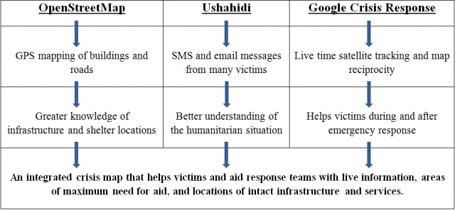
By examining the fundamental issues related to the Haitian recovery process, I drew up a solution that combines the properties of several great crisis mapping software, including Ushahidi, OpenStreetMap, and Google Crisis Maps. The basic concept is as follows:

By combining mapping techniques utilized by Ushahidi, OpenStreetMap, and Google, a much more useful crisis map could be created. Live tracking and satellite imagery create a useful canvas for crisis mappers to begin working on. Geographic information recorded by GPS mapping combats logistical issues hounding relief organizations. The victims would send in valuable information via preset emergency SMS shortcodes, giving crisis mappers a better picture of where medical aid and supplies are needed. Crisis map reciprocity informs both victim and aid workers of important events and their locations. By combining the techniques utilized by multiple individual mapping teams, an incredibly useful crisis map would be synthesized. And because both relief efforts and victims benefit from this synthesis of mapping techniques, many lives and resources would be saved.
Link to the full research paper here: https://docs.google.com/open?id=0B9CcwOgLmqAQNi1oT2tLZUw2NU0
Questions or comments? Please email them to kyuan@mit.edu