For a long time, genocide has been put in the box of great dark operatic human evils… We are the meteorologists of human rights abuses.
This week’s Thursday lunch was with the Satellite Sentinel Project. Based at the Harvard Humanitarian Initiative, they correlate data from satellites with other sources to track human rights violations, sometimes before they happen. Where possible, they threaten potential violators with exposure, release reports to the press, or pressure international organisations to take notice. By doing this, they hope to prevent genocides, stop large scale human rights violations once they begin, or at least to document atrocities after the fact.
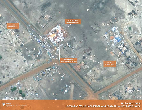
Looting at a World Food Program storage facility in Abyei town, 27 May 2011
Investigations start when the Harvard team or their partners get a lead on activity related to mass atrocities. The group then directs Digital Globe to point their satellites at related places of interest. If the weather is good and DG’s satellites aren’t already allocated by their other customers, DG can provide Satellite Sentinel with images within a very short period. The Harvard team then looks for evidence of atrocity-related activities and correlates it with reports from partners like The Enough Project. Once they can confirm the importance of the satellite images, they work with other organisations to pressure governments and the UN to respond.
Here are some of the things they look for, often comparing images over time to detect significant change:
- Repairs on elevated roads, to enable movement of military equipment and transport for looted goods
- Road graders, for the same reason
- Irregularly sized white and brown bundles (bodybags, which brown with reuse)
- Irregular patterns indicating mass graves
- Damaged and burned structures within a village, where the damage is discriminatory
- Movements of military equipment
- Unusual buildup of trucks, tanks and aircraft at military bases
- Clusters of refugee groups
According to Charlie Clements, executive director of the Carr Center for Human Rights Policy, the Harvard team is still working out their theory of change for Satellite Sentinel. Together with their funders Not on Our Watch, a human rights advocacy group, they hoped that if “what happened in Rwanda been mapped and tweeted in realtime, Rwanda wouldn’t have been allowed to continue.” However, they have found that the threshold for publicity and response only includes the most horrible atrocities — after they happen.
It is difficult to gather a picture of Satellite Sentinel’s work over time, since their publications reflect the immediate, urgent situations in which they are written. Furthermore, their website doesn’t permit users to sort search results by date. To gain a better understanding of their theory of change, I made a timeline of Satellite Sentinel’s work in Sudan this year: the North Sudanese government’s action to bomb, burn, and loot the border region of Abyei in late May 2011, displacing around 100,000 people from their homes. By following the timeline, we see the Harvard team constantly developing new approaches to address a rapidly-changing situation involving dozens of powerful state and non-state players:
- Background: BBC News: Why Abyei is Crucial
- Background: Jan 2011: Southern Sudan votes for independence. The fate of the border area Abyei is left undecided.
- Nov 22, 2010: Arms buildup in Abyei reported by Satellite Sentinel
- Abyei, March 2011:
- Mar 2, 2011: Intense Fighting reported in Abyei Region. Motivations unclear.
- Mar 4, 2011: Satellite Sentinel releases Flashpoint: Abyei, showing before and after satellite images showing that civilian structures were systematically targeted by Northern forces
- Mar 7, 2011: Video corroborates satellite evidence of burned villages.
- Mar 10, 2011: Satellite Sentinel detects evidence of military escalation in Abyei region.
- Mar 11, 2011: Satellite Sentinel Project Confirms Intentionally Burned Villages in Contested Abyei Region. Systematic targeting of civilians in three communities confirmed.
- Mar 22, 2011: Northern Sudanese officials deny any military buildup near Abyei. Satellite Sentinel reveals evidence of a military buildup.
- Mar 26, 2011: Satellite Sentinel partner the Enough Project issues a field dispatch based on interviews in Abyei.
- Mar 26, 2011: Satellite Sentinel correlates satellite evidence with ground photos to identify Northern SAF involvement in village destruction and looting
- Apr 1, 2011: NGOs in the Abyei region publish testimonies from the violence in Abyei and report on the path of displaced people.
- Apr 7, 2011: Satellite Sentinel reports a buildup of weaponry by the Northern Sudanese Armed Forces. They warn that the following month is a high risk window for renewed military activity.
- Apr 8, 2011: Satellite Sentinel Report: “Range of Attack: Deployment of SAF Attack Helicopters, Tanks near Abyei“
- Abyei, May 2011:
- May 19, 2011: Northern SAF forces attack Abyei with artillery, tanks, and aerial bombardment
- May 20, 2011: Abyei villages reported bombed and shelled by the SAF
- May 25, 2011: Satellite Sentinel documents the bombardment of towns in Abyei, followed by looting. (satellite images on flickr here)
- May 25, 2011: The Enough Project uploads photos from Abyei villages taken on 23 May
- May 25, 2011: Satellite Sentinel documents further SAF military buildup near Abyei
- May 26, 2011: Satellite Sentinel publish a report arguing that their evidence points to possible war crimes by the SAF
- May 29, 2011: Satellite Sentinel releases new evidence, arguing that “the totality of evidence from satellites and ground sources points to state-sponsored ethnic cleansing of much of the Abyei region“
- June 1, 2011: A bipartisan group of former civilian and military officials affirm Satellite Sentinel’s analysis suggesting war crimes by the Government of Sudan
In the above timeline, we see Satellite Sentinel’s advocacy shift from warning to documenting to accusing in the course of an event they monitor:
- warning over a month in advance of possible aggression, based on images of military bases
- after the outbreak of violence, confirming anecdotes by use of satellite images
- clearly identifying aggressors
- documenting the scale of structural damage
- compiling a comprehensive picture within days of an event, based on testimony, photographs, and satellite imagery, sometimes even before UN forces are released to make ground observations
Overall, the team at Harvard (and players in the situations where they intervene) are probably still figuring out just what role can be played by an NGO with access to directed satellite imaging. In the long term, Satellite Sentinel hopes they can use their techniques to deter future genocide. Some time before the aggression on 19 May, they warned Sudanese President al-Bashir that they were watching. Although we cannot know for sure, they hypothesize that this may be one reason the body count was much lower than it has been in the past.
We asked Nathaniel why national intelligence organisations aren’t doing this kind of work. The answer is understandably complex and left us with many unanswered questions. Firstly, Nathaniel suggested that military intelligence is too target focused to have the technical capability to monitor civilian welfare. But judging from the objects tracked by Satellite Sentinel, such as roads and military equipment, I reckon militaries can do this just fine. Secondly, Nathaniel said that intelligence agencies often must keep the information classified until an organisation like Satellite Sentinel puts them into the public record. I personally see a third great constraint which Nathaniel didn’t mention: the limited supply of directed satellite imaging. If governments and corporations don’t include human rights protection into the mission of satellite intelligence, attention will be spent elsewhere.
Satellite Sentinel isn’t the only group using technology to map crises. Crisis mapping software such as Ushahidi aggregates and visualises crisis reports from the web and mobile phones. Grassroots Mapping is a low-cost balloon-based platform developed for collecting high resolution map data. It was used to map the 2010 BP Oil Spill in North America as well as protests in Chile. Unlike Ushahidi, Satellite Sentinel can observe areas without mobile coverage. And while grassroots mapping may complement satellite data very well, satellites can observe areas without violating a country’s sovereign airspace.
The limitations of satellite surveillance arise in unpredictable ways. Clouds can obscure the picture. With limited satellite time, the Harvard team is often passing up on leads in order to pursue the greatest and most likely threats. Thus far, they haven’t applied computer vision techniques, and they only have so many trained eyes.
Satellite Sentinel also faces ethical challenges. As Nathaniel puts it, they are spying on behalf of the public for the good of humanity. This raises important questions:
- Just what *is* a public espionage organisation, and should such a thing exist?
- What are the ethics of releasing satellite data during an active conflict?
- Might military forces use the data to set their targeting systems?
- What if the data is used to track down refugees?
- What could happen if a false positive leads people to flee their homes en masse?
- Just what kind of practical ends should an organisation hope to achieve by processing and sharing this data?
- Is it even possible to develop a code of ethics for emerging situations?
Although Satellite Sentinel project has gained significant press for its work in Sudan, they have a larger vision for developing a paradigm for satellite imaging in humanitarian causes. At present, they are working to develop a long-term funding model for access to satellite information, establish a strong legal and ethical framework for their work, and to apply the lessons of the Sudan to second generation technology for humanitarian satellite surveillance.